Trip Planning Guide
These are my procedures for RV trip planning. They may or may not work for you. Use your own judgement when planning your camping trip.
I use RVTrip Wizard to plan the high level point to point stops for a trip. This tool helps me visually see the distance and route between stops (how long I will be driving), and plan for fuel stops, overnight stops, etc. I use RVTrip Wizard to identify potential fuel stops, but I do not use it for identifying overnight stops, or water/dump stops. For overnight parking, camping, and water/dump stops, the first tool I use to research these options is Campendium.
USA Climate | Elevation Heat Map (topography) | US Geological Survey |
Overnight Parking
Walmart | Costco | Bass Pro Shop (policy changed - now fewer) | Casinos | Cracker Barrel | Gander RV | Flying J Truck Stops / Pilot Travel Centers | Love's | TA Travel Center | ioverlander | |
Allstays overnight RV parking list
Elks Lodge overnight parking requires a membership.
19 Places You Wouldn’t Expect To Find RV Dry Camping Available
BLM National Data Viewer (map)
Configure the map layers as shown to see ONP areas:
Identifying Boondocking Locations
The trick to finding a legal boondocking location in the wild (vs a commercial district) is to identify who manages the land, and what restrictions exist. Begin by exploring an outdoor location using the PAD-US Map Viewer to identify who manages the land. Focus on lands managed by the 'Bureau of Land Management (BLM)', 'US Forest Service (USFS)', and State Lands because they provide the best opportunites for boondocking.
US Forest Service OHV Maps By State
US Forest Service OHV Maps By State Online Interactive Map
BLM Camping Guidelines
- Find the local field office and ask the rangers.
AZ Trust Lands
Campendium has Arizona Trust Lands overlays options for their online map layers. Family permits good for 14 days can be purchased online for $21.
Navigation
It is important to be able to navigate your vehicle on the road, vehicle (Jeep) on a off-road trail, and while biking/hiking on a trail in an area were you have no cellular signal. A great solution is using an app on your smartphone that uses the GPS in your phone (doesn't require a cellular signal) to show your location on a map. In this way, you can follow a trail, or find your way to a particular location of interest.
Georeferenced PDF Maps
You can find a lot of these maps for free (and paid) that provide a valuable guide when navigating the outdoors. For example, the Bureau of Land Management (BLM) provides a free library of these maps. The free version of the mobile app Avenza allows you to access up to three maps at a time (so you need to plan your download of the maps in advance). Note that it is also possible to make your own maps from non-georeferenced PDF maps and map images using other applications. I had a bad experience with Avenza. From the moment I first opened the app, it crashed. I was able to open one map on it, and thereafter it crashed every time I opened the app. Uninstalled the app and gave up.
AllTrails
AllTrails is both an online resource, and a smartphone app that together provide fantastic trail navigation capabilities. You need to download the map to your phone prior to losing cellular / WiFi service, but after that you have solid trail navigation support. The details by location allow you to see pictures of what you can expect, user comments, and you can filter the locations by activity (hiking, biking, OVH, road, etc.). Not limited to trails, many scenic road trips are included. You can also review the elevation for the trail/road path to help you decide if it is what you want. The hudge library of trails and information makes it worth upgrading from the free version to paid.
NOTE: Clicking on the download icon (down arrow) when a map/track has been downloaded allows you to delete it from your phone.
GPX File GPS Tracking Apps
Elevation
The online tools that are actually useful for evaluating the elevation along a route or at particular points are the following:
511 is a transportation and traffic information system that is intended to be a nationwide resource. Although federally established, it is not funded and no signification requirements or expectations have been defined. All existing resources are provided at the state and local level. A map with links to 511 travel information services is available online.
Road Conditions
511
Dump
SaniDumps.com | ioverlander | https://rvdumpsites.net/ | Map of RV Dump Sites | Google Map | By Zip Code | Flying J Truck Stops / Pilot Travel Centers | Camping World
Water
Propane
Pilot / Flying J
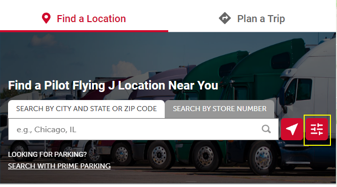
Start a search and then configure the filter to search for "Bulk Propane".
Enter a location to search and then click the magnifying glass icon to the right of the field entry area. Review the store details and you can confirm it sells bulk propane (fills an RV) by observing that 'Propane' is listed under 'Fuel Prices' AND that it is listed under 'Amenities'. Note that under 'STORE DETAILS' the address and GPS coordinates are listed.
Love's
Perform a search from Love's website and check the 'Amenities' option 'Bulk Propane'. Click the 'Search' button at the bottom of the page and a map will appear with the Love's locations that sell bulk propane (RV refill). Get the store # (station code) and then serach for it on this page to see what other ammenities are available.
iOverlander
Go to iOverlander and check the 'Place Types' options for 'Propane'.
ALLSTAYS
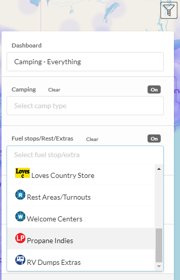
ALLSTAYS has a filter 'Propane Indies' for PRO subscription only that displays places that sell only propane (not other types). The ALLSTAYS help document FINDING ALL PROPANE LOCATIONS provides more information on how to search for propane suppliers.


.png)
.jpg)
.jpg)
.jpg)
.jpg)
.jpg)
.jpg)

.png)
.png)
